
An island nation having historically highest number of 72 active volcanoes, Indonesia gives us the chance to see Earth’s volcanic activity from a very close angle. Though volcano tour packages are gaining popularity but the fun lies in exploring the route on your own and enjoying the road as you go.
Mt Bromo and then Kawah Ijen or the Ijen crator are the most visited volcanoes in Indonesia. Most google searches on this route points out to package tours with end to end travel by jeep and the tourist end up spending upto three times the actual cost. We decided to ditch the usual route and the package trips from Surabaya and did it the other way round from Bali to Kawah Ijen and then Probolinggo to Mt Bromo.
Bali to Java island
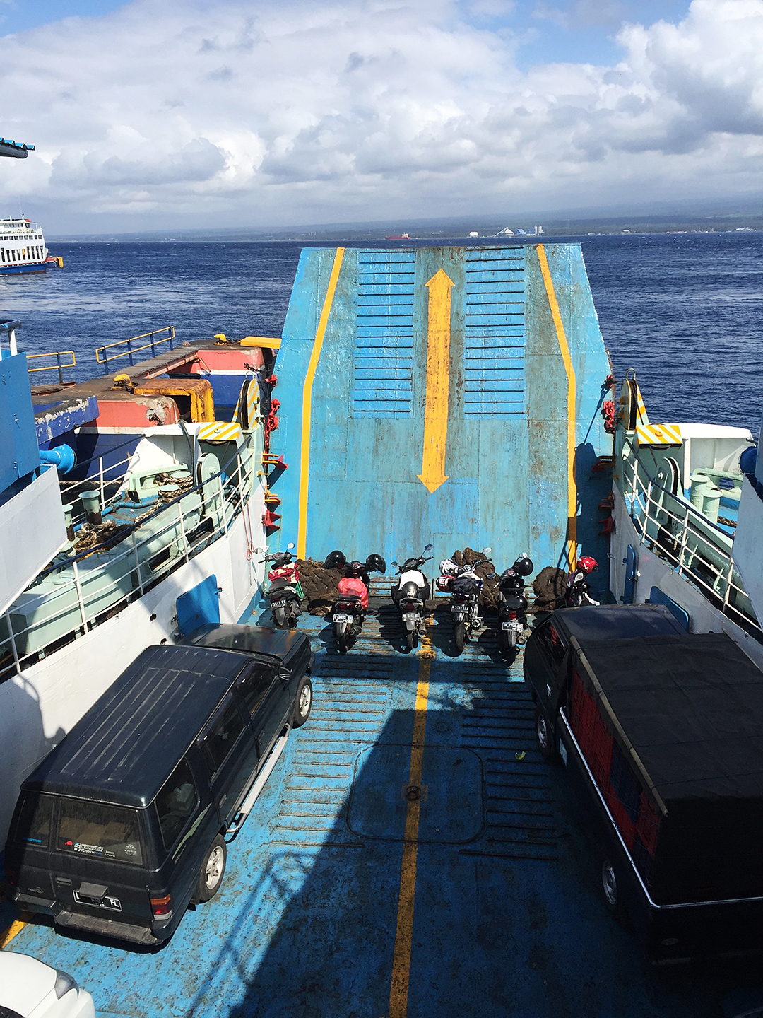
There are buses from the Denpasar terminal in Bali which gives you a ticketed ride till Probolinggo in Java and it includes the ferry ride but not much information is available online on routes and schedules so we took a cab-ride to the Ketapang port of Bali. All foreign nationals have to fill up a extra form other than the ticket form. The port is quiet modernised and it took only a few minutes to buy tickets and the board the ferry. Heavy vehicles also go onboard the same ferry. The ferry crossing takes 10 minutes but docking takes time but the whole process should get over in 30 mins flat.


The port town in Java is called Banyuwangi and Kawah Ijen is an hours drive from this town. We checked into our homestay during noon. The city centre of this town is marked by a grand mosque and a park area on each side of the main arterial road. Unlike Bali this town doesn’t have any forex shops and many banks cannot take your dollar or euro bills for many unforeseen reasons.
Get your money exchanged at a gold shop here at the city centre at Toko Mas and the lady gives a good rate too.
As the sun set we decided to have dinner but this quiet town has very few restaurants and cafes. A few minutes walk away from the mosque we found Javanese Gudeg food at a restaurant named Sego Bunkus Bo Poer. Run by Mrs Poer this is a traditional Java cuisine its spicy and has more sugar than other cuisines. An array or veg and non-veg dishes are displayed across the counter. Traditionally it has 3 varieties of rice, vegetables including jackfruit, beans, greens and many non-veg curries containing chicken, mutton and beef. They also serve quail eggs. The food is cooked morning and evening by the lady herself.
While walking back we booked our onwards train journey to Probolinggo. Train tickets can be bought in advance from supermarkets like Alphamart or Indomaret. Though this is not the boarding pass and that you can get once you scan this paper slip at the automated ticket counters inside the station.
We had booked a tour to the park through our homestay host and were picked up f at 12:00 midnight by our touring company. From the town it’s about an hours ride to the meeting point. Cars from all touring companies stop at this common point next to the gate of the national park. We were made into a groups of 20 and each group was assigned two guides. One of the guides is a local ex-miner. Covered up in warm jackets in cold dark rainy night, we waited in different small eating shacks enjoying tea/coffee when we were distributed masks which is a must wear at the crater. We bought raincoats or rather rain covers from the shack, cheap ones to last one or two trip. Gloves socks and jackets are also available on hire.

Trek to Kawah Ijen, the acid lake
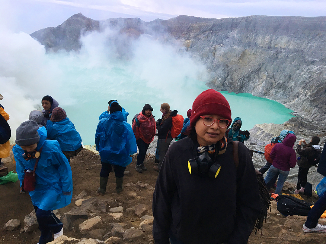
This journey is to the Ijen crater or Kawah Ijen as the locals call it, the largest acidic crater lake in the world. Standing atop Gunung Merapi, there’s sulphur fire burning on one side which is only visible at night. We started our hike through the national park in groups with one guide on front and one guide at the back and it was pitch dark around us. On this narrow winding hike along the hill slope the only light source was the tour guides torch.
The hike to the crater is very steep and we couldn’t we see the ground clearly but could feel that it was a muddy path created by the sulphur miners walking up and down carrying sulphur for the last few centuries. We walked slowly uphill putting all the weight on our knees and stop at every few hundred metres gasping for breadth. It was drizzling all along and as we hiked up the wind gathered strength. Armed with torches, the guides, both at front and back kept motivating us to keep moving at a slow pace.
After about 1.5 hours walk we were told that we had reached top of the hill. In the vast darkness we found ourselves standing up on a flat land with the torch lights flashing around and we thought we were feeling triumphant thinking we had reached the crater. The rains have stopped but the high wind is still there. Just then the guides announce that now we will have to climb down and its the decent of around 700 metres to the lakeside. Now all we could see was rocks all the way down into some darkness. We had to land on the big and small rocks in a single line to move downhill, one person at a time. Hold on to the rock-face for support and sometimes even slide down on all fours. It’s just a path created by the sulphur miners walking up and down this barren sharp-edged rocks for many generations. There are ropes at some points to hold on to where there is a sharp drop. This part of the hike took us the longest time and it looked like we were headed to the end of the world. So keep your calm and move on.
As we moved down and reached a flat land, suddenly we could see rising blue flames in front of us. Many people carry their SLR cameras with tripods and sit there for hours to catch a good shot of the flames. The blue flames looked like a supernatural phenomena and will keep blowing in different directions because of the wind. We just stood there fighting cold and were amazed looking at the flames. It’s as if we were at the earth’s end and it’s slowly releasing its energy through tiny fissures.

The sky was clearing up and the tourist crowd started fighting for space so we decided to retreat and walk up the hill. Now we could see the sulphur miners down in the the valley working closer to the blue flames. We walked back uphill following our guide this time we moved faster since we had got familiar with the terrain and the sky was opening up. The hike downhill to the flames is recommended in the dead of the night because in daytime it looks like a herculean task.

With the sun rising one couldn’t see the flames anymore although its burning as you can see the miners constantly at work collecting deposited sulphur and bringing them up on their back. Some of them make and sell cute figures using those sulphur rocks.


The walk back to the base camp was faster and now we didn’t need to follow the guide this time. We enjoyed the jungle’s flora and fauna as we brisk-walked down steep rolling muddy path. It’s almost impossible to walk slow but jogging or running down seems easier. It started drizzling again as we came down to a lower altitude. We returned our masks at the shack and head back to our homestay in the same car by 9 AM.
Train ride to Probolinggo
After a hearty breakfast provided by our host, we checked out to reach the Karangasen station which was only 20 minutes away. It’s a small station with only two platforms. The trains are all AC chair cars with full reclining seats and lots of leg-space. Food can be bought on board at an extra cost. And the AC has no temperature control so it gets freezing cold eventually.


Probolinggo to Cemoro Lawang
On reaching Probolinggo at 1 PM we took a short bemo ride to reach the bus station from where we could hire another ride to the hills. At the bus station there were no buses till Cemoro Lawang. Standing outside the bus station we were approached by some more foreign backpackers who wanted to share their 15 seater bus ride with us. This small vehicle can actually fit-in only 8-10 but 12 of us decided to take the ride to save cost. The driver wouldn’t budge from the amount he declared because he figured he was the only one around to take us to the hill town. The 2.5 hrs drive to Cemoro Lawang in a ‘chicken bus’ had me and my husband stuffed in between seats hardly moving our legs. The ride up the hilly roads was very picturesque so we forgot about our inconveniences and started sharing our travel stories.
We had no bookings for the night but we wanted to stay close to Mt Bromo and we headed straight to the hotel that we could see was closest to the park gates. It was raining with heavy fog and the skylight was vanishing fast.
Every tourist has to pay a small amount of entry fee at the gates before entering this hill town of Cemoro Lawang
Cemara Indah Hotel, our home for the night is just outside the park and it faces the Mt Bromo national park. Though this town is full of guest houses and home-stays, we were lucky to find a room in Cemara Indah because its has one of the best views of Mt Bromo. Though top end, one shouldn’t expect much luxury in here. The staff is very courteous and they themselves provided us with jackets realising the one we have is not enough to keep us warm. Hot water was bought in buckets for us to clean-up and take rest for the night. On a clear day one get a great birds eye view of the ‘Sea of Sand’ and Mt Bromo from this hotel. Mount Bromo is surrounded by its own volcanic ash for a few kms which is named as ‘Sea of Sand’.

Hike to Mt Bromo
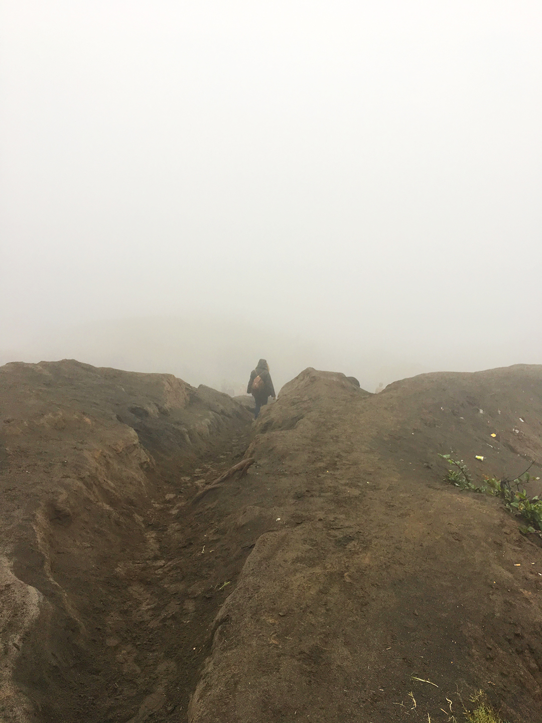
At 3:00 AM we were woken by the hotel staff and we boarded the jeep to take a 30 mins ride to the nearby hill of Mount Penanjakan which is the viewing point for Mt Bromo. Once we reached Mount Penanjaken we realised its going to be a rainy day so no viewing is possible. We waited till the sky lighted up a bit but we were still engulfed in a thick blanket of fog with intermittent rains and very high winds so we decided to drive down to the mouth of the crater as soon as possible before the rains get harder. At least a thousand cars were lined on the hill slopes on both sides of the road and a many a shops alongside were doing brisk business selling soups and noodles as the travellers waited patiently for a view. We rushed past the scores of parked jeeps and buses to reach the volcanic ash field. A few kms into the vast flat field surrounded by the fog all the jeeps were parked and we were asked to walk. Some tourists decided to take a horse ride. It was a straight walk on the ash coloured sand ground that led us to the climb.
On dry days its advisable to carry a breathing mask due to shield against ash laden winds. The barren brown and ash coloured martian landscape with a few green hills in the horizon on a heady fog day made the atmosphere quiet surrealistic. It’s an easy walk and the last climb is about 240 plus stairs. During tourist season you would be walking slowly in a que as the stairs are narrow enough allow only one person on each side of the two way traffic.
Once we reached the top, we realised there was a narrow walking strip around the crater. Due to heavy fog the visibility around us was only a few hundred metres but we could roaring lava noise coming from the base of the crater. It was like a thousand thunderstorms brewing a few hundred metres below us. It’s a scary and an exhilarating experience, mankind feels tiny and inconspicuous in-front of this vast active volcanic lava spewing hole down the slopes. It’s highly windy and volcanic ash ground is very slippery so we took a slow walk and decided to come down the slope to give way to the ever-growing crowd of hikers. The whole hike from the car park and back takes about 2-3 hours depending on the speed at which you hike and the time you spend on the crater.


Once you come back to the hotel by 9:00-9:30 am, the hotels will be ready to serve you hot breakfast and nothing tastes better than the local fare they serve. You can take rest for the day or head out in a towards Probolinggo.

Things to remember
- Check the local weather before you plan, the volcanoes have a their own weather condition.
- Trains are mostly on time.
- Bemo/small buses to Cemoro Lawang have no timing. They leave only when they are full. If you want to leave early the pay for a full Bemo and they will take you without waiting for other passengers.
- It’s spine chilling cold on the top and it rains all of a sudden so be covered up properly and carry rain cover.
- It’s advisable to carry a torch for Kawah Ijen trek.
- You can decide not to take the jeep tour and just walk to both the viewing point and the crater and save money if you have time in hand.
- There’s instant noodles and snack shops at the ‘Sea of Sand’ car park.
- There’s a basic toilet along the trail midway very close to the car park… though they are building better ones now.
